


Diggins Voting District, Webster County, Missouri
About
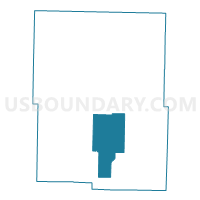
Outline

Summary
| Unique Area Identifier | 611584 |
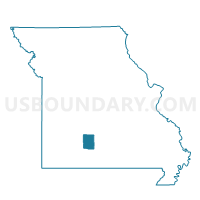
| Name | Diggins Voting District |
| County | Webster County |
| State | Missouri |
| Area (square miles) | 39.63 |
| Land Area (square miles) | 39.56 |
| Water Area (square miles) | 0.06 |
| % of Land Area | 99.84 |
| % of Water Area | 0.16 |
| Latitude of the Internal Point | 37.18527530 |
| Longtitude of the Internal Point | -92.85922560 |
Maps

Graphs
Select a template below for downloading or customizing gragh for Diggins Voting District, Webster County, Missouri


Neighbors
Neighoring Voting District (by Name) Neighboring Voting District on the Map
- Dallas/Green Hills Voting District, Webster County, MO
- East Ozark Voting District, Webster County, MO
- Finley Voting District, Webster County, MO
- Hazelwood Voting District, Webster County, MO
- High Prairie Voting District, Webster County, MO
Top 10 Neighboring County Subdivision (by Population) Neighboring County Subdivision on the Map
- Hazelwood township, Webster County, MO (2,846)
- East Ozark township, Webster County, MO (2,652)
- Diggins township, Webster County, MO (2,552)
- Finley township, Webster County, MO (2,435)
- Dallas township, Webster County, MO (1,653)
- Green Hill township, Webster County, MO (1,492)
- High Prairie township, Webster County, MO (1,102)
Top 10 Neighboring Place (by Population) Neighboring Place on the Map
Top 10 Neighboring Unified School District (by Population) Neighboring Unified School District on the Map
- Marshfield R-I School District, MO (16,818)
- Seymour R-II School District, MO (6,617)
- Fordland R-III School District, MO (4,467)
Top 10 Neighboring State Legislative District Lower Chamber (by Population) Neighboring State Legislative District Lower Chamber on the Map
Top 10 Neighboring State Legislative District Upper Chamber (by Population) Neighboring State Legislative District Upper Chamber on the Map
Top 10 Neighboring 111th Congressional District (by Population) Neighboring 111th Congressional District on the Map
Top 10 Neighboring Census Tract (by Population) Neighboring Census Tract on the Map
- Census Tract 4703.02, Webster County, MO (4,635)
- Census Tract 4704.01, Webster County, MO (3,773)
- Census Tract 4704.02, Webster County, MO (2,989)